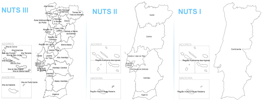
NUTS stands for "Nomenclature of Territorial Units for Statistics", a legal framework for the geographical division of the territory of the European Union into regions.
This nomenclature was created by Eurostat in the early 1970s in order to harmonise the statistics of the various countries for collection, transmission and publication purposes of regional statistics.
It is subdivided into 3 levels (NUTS I, NUTS II, NUTS III), defined according to population, administrative and geographical criteria. The NUTS III are called “administrative units”. These administrative units correspond to the “Intermunicipal Authorities”, the “Autonomous Region of the Azores” and the “Autonomous Region of Madeira”.
In 2024, a new regional division came into force in Portugal – the NUTS 2024, replacing the territorial tree in force until then (the NUTS 2013). This territorial reorganisation is fairly common: in 2015, the NUTS 2002 had been replaced by the NUTS 2013.
Compared to the previous version – the NUTS 2013 – the 2024 version corresponds to the creation of the NUTS II covering “Grande Lisboa”, "Península de Setúbal” and “Oeste e Vale do Tejo”.
As for the NUTS III, “Grande Lisboa” and “Península de Setúbal” were created, coinciding with the boundaries of the respective NUTS II.
The new NUTS II “Oeste e Vale do Tejo” now comprises the NUTS III “Oeste”, “Lezíria do Tejo" and "Médio Tejo", which already existed but belonged to other NUTS II. The boundaries of the NUTS II “Centre” have thus changed, with the exclusion of the NUTS III “Oeste” and “Médio Tejo”, and the NUTS II “Alentejo” with the exclusion of the NUTS III “Lezíria do Tejo”.
The designation NUTS III “Alto Tâmega” (2013 version) changed to “Alto Tâmega e Barroso” (2024 version), but not its composition.
Finally, the municipalities of Sertã and Vila do Rei moved from NUTS III “Médio Tejo” to NUTS III “Beira Baixa”.
Therefore, Portugal's 308 municipalities are currently grouped into 26 NUTS III, 9 NUTS II and 3 NUTS I.

|
NUTS III |
NUTS II |
NUTS I |
|
Alto Minho
Cávado
Ave
Área Metropolitana do Porto
Alto Tâmega e Barroso
Tâmega e Sousa
Douro
Terras de Trás-os-Montes
|
Norte |
Continente |
Região de Aveiro
Região de Coimbra
Região de Leiria
Viseu Dão Lafões
Beira Baixa
Beiras e Serra da Estrela |
Centro |
Oeste
Médio Tejo
Lezíria do Tejo |
Oeste e Vale do Tejo |
|
Grande Lisboa |
Grande Lisboa |
|
Península de Setúbal |
Península de Setúbal |
Alentejo Litoral
Baixo Alentejo
Alto Alentejo
Alentejo Central |
Alentejo |
|
Algarve |
Algarve |
|
Região Autónoma dos Açores |
Região Autónoma dos Açores |
Região Autónoma dos Açores
|
|
Região Autónoma da Madeira |
Região Autónoma da Madeira |
Região Autónoma dos Madeira
|